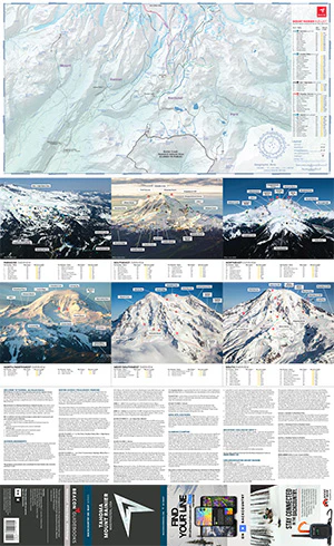
Tahoma/Mt Rainier Backcountry Ski Map
Tahoma, or Mount Rainier, known for its coveted extreme skiing objectives and 9,000’ of vertical relief, draws aspiring ski mountaineers the world over. This newly released ski map includes 130 routes in 14 zones with meticulous details and cartography. From entry-level day tours to bucket-list adventures, the Backcountry Ski Map brings it all to your hands in a 2 oz. compact pocket companion.
This 1:32,000 scale map written and reviewed by professionals is an essential planning tool designed to join you on your tour and details ski descents and approaches, slope angles, Avalanche Terrain Exposure Scale ratings, key landmarks, and so much more. Author Matt Schonwald addresses important trip planning essentials, provides trailhead and access information, and outlines the climbing, camping, and guide resources you’ll need to get started. Six amazing aerial photos of all aspects of the mountain, with routes identified, help with overview tour-planning and visualizing the landmarks and hazards for each zone.
This 22” x 36” waterproof, foldable topo map includes the following zones: Pan Point, Paradise Valley, Muir + High Alpine, Nisqually + Success, Little T, Summerland, Owyhigh, White River + Sunrise, Emmons, Carbon, Spray Park, Mowich, Tahoma + Sunset, and Tatoosh.
Product Information
Product Information
Shipping & Returns
Shipping & Returns
Description
Tahoma, or Mount Rainier, known for its coveted extreme skiing objectives and 9,000’ of vertical relief, draws aspiring ski mountaineers the world over. This newly released ski map includes 130 routes in 14 zones with meticulous details and cartography. From entry-level day tours to bucket-list adventures, the Backcountry Ski Map brings it all to your hands in a 2 oz. compact pocket companion.
This 1:32,000 scale map written and reviewed by professionals is an essential planning tool designed to join you on your tour and details ski descents and approaches, slope angles, Avalanche Terrain Exposure Scale ratings, key landmarks, and so much more. Author Matt Schonwald addresses important trip planning essentials, provides trailhead and access information, and outlines the climbing, camping, and guide resources you’ll need to get started. Six amazing aerial photos of all aspects of the mountain, with routes identified, help with overview tour-planning and visualizing the landmarks and hazards for each zone.
This 22” x 36” waterproof, foldable topo map includes the following zones: Pan Point, Paradise Valley, Muir + High Alpine, Nisqually + Success, Little T, Summerland, Owyhigh, White River + Sunrise, Emmons, Carbon, Spray Park, Mowich, Tahoma + Sunset, and Tatoosh.